Climate risk management for infrastructure decisions.

Degree Day provides weather and climate datasets, expert analysis, and independent validation for organizations making infrastructure and investment decisions.

Explore Services
Blue arrow to the right
Blue blur circle

Climate Risk Assessment

Resilience begins with long-term planning. Our End-to-End Climate Risk Assessment and service is designed to help organizations comprehensively understand and address extreme weather and climate-related risks.
Find Out More
Blue arrow to the right
Blue blur circle

Extract meaningful insights from your vendor data

Your vendor data holds untapped potential. We help you unlock it— transforming risk scores, indicators, and other raw information into actionable insights that drive smarter decisions, cost savings, operational efficiencies, and more.
Find Out More
Blue arrow to the right
Blue blur circle

What we deliver.

Avoid Costly Infrastructure Failures

Identify climate risks to critical assets before they cause operational disruptions or capital losses.

Defend Your Climate Decisions

Independent technical validation for board presentations, rate cases, and investor disclosures.

Prioritize Adaptation Investments

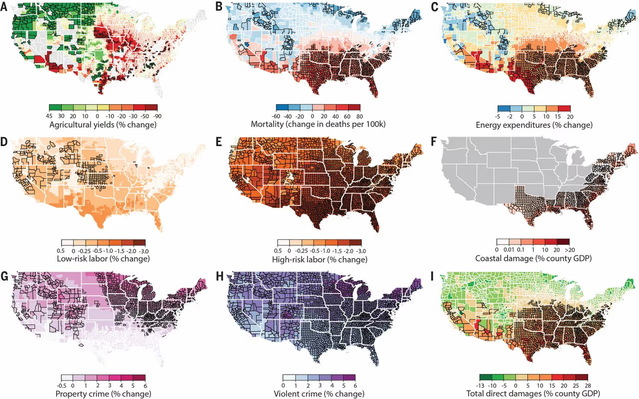
Quantify climate risks to identify which assets need protection first and how much to spend.

Get Engineering-Grade Climate Data Fast

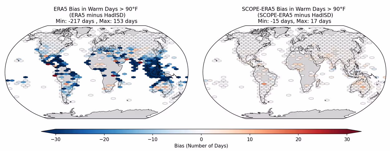
Station-calibrated datasets in formats engineers actually use. Delivered in minutes, not months.

Meet Disclosure Requirements with Confidence

Rigorous analysis, clearly explained from a climate scientist with 15 years of experience, not a generalist consultant.

Ellipse vectorEllipse vector

From engineering-grade data to expert validation

Built on Observations, Not Just Models.

Transform climate data into clear, defensible decisions:

Physical Risk for ERM Frameworks

Quantify physical climate risks in language that fits enterprise risk management systems.

Climate Disclosure Support

Technical data and documentation for TCFD, SB, CSRD, and other regulatory requirements.
Lays of ground
Ellipse vectorEllipse vectorEllipse vectorBlue blur ovalBlue blur circle

What We Help With

Assess Asset-Level Climate Exposure

Identify which assets and investments face the highest physical climate risks.

Search glass with statistics blue icon

Design for Future Flood Risk

Use forward-looking flood projections for infrastructure design and site selection

Flood blue icon

Integrate Climate Risk into ERM

Quantify physical climate risks in financial terms for enterprise risk management

Raising money blue icon

Estimate Climate Impact on Operations

Assess how changing temperatures affect energy demand, cooling costs, and equipment performance

Sunny city blue icon

Update Infrastructure Design Standards

Incorporate forward-looking climate data into design and capital planning

Document with statistics blue icon

Support Climate Risk Disclosure

Provide technical data and documentation for TCFD, SB, CSRD, and investor reporting requirements

Document with auction hammer blue icon
Continents vector with climate

How Is Degree Day Different?

DegreeDay Logotype icon
People in front of a planet icon
Independent and objective. Free from vendor or VC bias
Multiple path icon
Grounded in observations, not just climate models
People conversing white icon
Direct access to the climate scientist doing the work, not a sales team
Blue blur circle

Solutions For Many Use Cases

Raising money white icon

Portfolio & Asset Management

Document with auction hammer white icon

Physical Climate Risk Disclosure

Sunny city white icon

Infrastructure & Resilience Planning

Umbrella white icon

Real Estate Development & Due Diligence

Error icon

Engineering & Design

Statistics white icon

Enterprise Risk Management

Read More About What We Do

Our research has been used by decision-makers in business, government, and non-profit sectors since 2011.

Explore Services
Blue arrow to the right
Blue blur circle

Read our climate change research

View All
Dark-blue link arrow
Estimating economic damage from climate change
Multivariate Bias Correction of ERA5 Using in-situ Observations
Observations reveal changing coastal storm extremes...
See level metrics image
Popular Extreme Sea Level Metrics Can Better Communi...
See level metrics image
Extreme Sea Levels at Different Global Warming Levels.
Probability-Weighted Ensembles of U.S. County-Level...
Economic Risks of Climate Change: An American...
Extreme sea level implications of 1.5 °C, 2.0 °C, and 2.5 °C...